After admiring her maps for several decades I began to ponder why the great Ruth Taylor White does not have a place in Tooley’s Dictionary of Mapmakers or even a Wikipedia page. After all, she must be considered at the top of popular cartographers with few peers amongst pictorial mapmakers. During the golden age of graphic arts in mapping, Ruth Taylor White stood above the crowd in her research, drawing skills and sense of humor applied to delightful cartographs that endear viewers to points all over the globe. Anyone who appreciates these whimsical masterpieces (me) has to marvel at her skill and prolificacy. The maps are part clever cartoons and part brilliantly colored landscapes that literally come to life on the page. Despite the lack of information on this obviously extraordinary woman her work continues to gain in popularity and desire from collectors with a caveat. Her legacy on paper is incredibly full, her biography is a little hard to determine and full of mysteries unless you have friends in libraries including Julie Huffman in genealogy and Kelly Wallace of the Stanford University Women’s mafia. Ruth Taylor White's work spans 1928 to 1945, a stretch that covers the golden age of pictorial mapping despite the constraints of the Great Depression and the fact she was female in the entrenched patriarchy. She most certainly stands amongst maybe a half-dozen masters of the craft and shares other characteristics with the artists of her genre and time.

Ruth Dena Taylor was one of five children born to John S. Taylor and Ellen Stobbs. The family had moved around a bit including places in the upper Midwest but in 1896 they were living in Salem, Oregon. In some sources, John is listed as a painter which would make sense as the three girls in the family were all extremely talented artists. Yet, in the next census, John is a “house” painter which may be made up by the census taker but all of the children were smart and possessed artistic temperaments. They moved to Los Angeles before World War I and lived in what we now call the South Park area. The oldest child was Frank who later became a successful journalist/writer who worked with Ruth many times and was sometimes referred to as “taking her under his wing.” I kind of doubt that but he began the trail of this brilliant bunch to Stanford University where he rose to editor of the school paper and was waiting when Ruth joined him on an Art scholarship in 1915. True to her independent nature she chose to study English at Leland Stanford University. Ruth was followed by two sisters, Bernice and Bella who received Art scholarships in the following four years. Frank went off to World War One, first as an ambulance driver and then as a widely read war reporter. Back home, Ruth was a real presence in Palo Alto, where she was a popular cartoonist getting student adulation for drawing the crowd at “the big game” and then becoming a series of editors on the Daily Stanford. Finally, Ruth was named editor of the Daily Palo Alto, the first and only woman in that post for half a decade. She was a star in campus society, as a member of the Delta Delta Delta sorority, and an honorary member of the Hammer and Coffin Society, created by the humor magazine The Chaparral. She went off to New York to the Institute of Art in 1919, her senior year, and returned to get an engagement ring from a young Leonard Maxwell White of Santa Cruz.

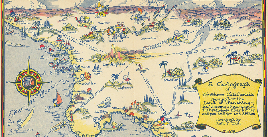
Ruth was always full of ideas and overflowing with artistic talent so when she and a friend Mrs. H.H. Hoss flew across the country, an ordeal in the early days of air travel, she became enamored at drawing cartographs of cities as she saw them from above. She planned a three-quarter aerial view with exaggerated characters making small comments about their surroundings. First, she got hitched to Leonard, June 6, 1919, and they moved to Phoenix where he went into the Insurance business. This was just one of the first times her dreams were deferred and instead of flying over cities and sketching she took on motherhood with Theodore arriving in 1921 and Nancy in 1925. On that birth certificate with a hefty art portfolio, Ruth is listed merely as “housewife.” Now, housewife is a noble calling and the favorite woman in my life was one of those but Ruth was primarily a brilliant artist. This draw toward her paints and pencils lead to a divorce of Mister White and Ruth sought a career as a working artist. The roaring twenties opened doors slightly for a selected few women so Ruth stepped through. The fascination for air travel helped her with a pair of fine cartographs for Western Air and one of Southern California for the Western Air Express commemorating the 3rd anniversary of airmail. The eight-hour flight from Salt Lake City to Los Angeles took some courage but Ruth seemed to relish such adventure. She kept the White surname and created scores of superb pictorial maps in the following decades mostly to draw tourists to exotic locations or to advertise commercial endeavors. Probably the most popular would be the set she created for the Hawaiian Tourist Bureau who lead her on tours of the islands for six weeks in the spring of 1930. A wildly popular brochure featuring a first draft lead to separate colorful lithographed sheets that remain popular today. Each of the four tourist destinations represented are part of the library's collection. At that time she also created a memorable map of the Philippine Islands for the Manila Hotel that was handed out gratis to visitors. Now, in the City Directories she was listed more accurately as “commercial artist,” and the jobs flowed in as she traveled forth. She did a beautiful tribute to the Monterey Peninsula in 1932 and the Earth in Hemispheres in the same year. Despite the Great Depression ravaging the country she earned a good living and lived independently in Northern California. Her cover for the California State Automobile Association of Motorland, California Winter Play Land uses colors that make this graphic call to California a siren song. She joined with her brother putting together a book on the National Parks, Oh Ranger, and another on the Grand Canyon. In 1935 they collaborated on her true masterpiece USA a Gay Geography that covers states and territories with her trademark colorful cartographs. It is here the asterisk must be inserted to alert viewers of Ruth Taylor White's place in a time of unenlightened social attitudes. This work sometimes features offensive images by today’s standards. They are products of a time of ignorance and insensitivity toward non-white people who are often portrayed in very broad stereotypes. Despite the whimsical, cartoonish depictions the images can only be described as “colonialist, racist, sexist and classist.” For the purposes of this blog, these images will not be repeated and certainly, they cannot be excused but they also must not be ignored. The maps beckon to tourists and paint natives and people of color with a broad brush like characters in Disneyland’s Small World. By all accounts, Ruth Taylor White was an upstanding and educated woman who possessed rare artistic talent but lived without questioning the bigotry of her times. Then again, the critical examination of these works by experts never raised a concern. All of the newspapers and journals I could find never uttered a discouraging word.

Ruth Taylor White continued drawing and traveling, flying bravely across the world to view places that few Americans visited like India, China, or Japan. At the peak of her mid-1930’s popularity, she met Doctor Horace Pitkin, a Yale and Columbia blueblood who put ring number two on her finger and settled in San Francisco where she later created another gem of the city by the bay. Apparently, Art won out over Pitkin and Ruth pulled the rip-cord on marriage number two and hit the road once more. Staying in Northern California she created a masterpiece for a booklet on the Golden Gate Exposition including Treasure Island in 1939. She took another whack at Monterey and produced a lovely poster for United Air Lines at the end of the decade. It is not easy to date most maps and in the case of pictorials sometimes more difficult. Even experts have a hard time pinpointing some of this artist’s work but sometime after working on the Exposition, she produced the very popular Wine Map of California that may hang on walls to this day. When World War II raged on she volunteered with the American Red Cross and accepted the difficult posting to India where she worked from the summer of 1944 to the end of the hostilities. While overseas she created probably her last color map, A G.I. View of American Red Cross China, India, and Burma. Her style has begun to change and the figures are more realistic and less cartoonish.
Ruth gave domestic bliss one more shot when at the age of 49 she married “Dud” Day at about the time the big ugly war ended and moved to St. Helena where she lived in marital bliss for the rest of her days. There, on voting records, she was once more listed as a housewife to her Dud. It is ironic that almost all art sources list her death date as 1950 which would surprise Ruth who appeared in Hawaii checking out map sales there in 1956. According to British scholar Dori Griffin who wrote the only truly thorough examination of Ruth Taylor White’s work the great cartographer made it to 89, leaving us in 1985 with apparently 35 bonus years on the art world.


