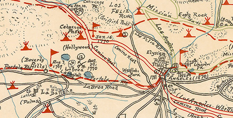
Kirkman-Harriman Pictorial and Historical Map of Los Angeles County. Los Angeles Public Library Map Collection.
Before Los Angeles, there was Yangna, home to the Tongva people, Native Americans who numbered at least 5,000 in the Los Angeles Basin before the arrival of Europeans. In the latest episode of Stories From the Map Cave, Map Librarian Glen Creason explores two maps which document the history and geography of the Tongva: the stunning Kirkman-Harriman Pictorial and Historical Map of Los Angeles County and the Gabrielino Indians at the Time of the Portola Expedition.
You can view other episodes of Stories From the Map Cave on our YouTube channel. There's also lots more to discover, experience, and explore about Native American Heritage Month at lapl.org/native-american.

The Gabrielino Indians at the Time of the Portola Expedition. The Tongva are also known as the Gabrielino or Gabrieleño, names derived from the Spanish mission built near them: Mission San Gabriel Arcángel. Los Angeles Public Library Map Collection.